top of page
South America
January 19 - March 1, 2026
Day 1, Monday, January 19, 2026
Start: Boston, MA
End: Hotel Panamby, São Paulo
Distance Flown: 7738 kilometers (4808 miles)
Major Highlights: Delta Filght 6059 (flown as LATAM 8165)
Our trip had an inauspicious begining.
A 2 hour delay leaving Boston and the 1.5 hours it took to deliver luggage in São Paulo, meant we missed our connection to Rio de Janeiro.
LATAM put us up in the lovely Hotel Panamby, São Paulo.
After a long day, we managed to get to bed at about 2 AM

Day 2, Tuesday, January 20, 2026
Start: Hotel Panamby, São Paulo
End: Copacabana Palace, Rio de Janeiro
Distance Flown: 337 kilometers (209 miles)
Major Highlights: Latam flight 3698, Arrival in Rio de Janeiro, tour of Christ the Redeemer statue and Sugarloaf Mountain.After a 5:30 AM wakeup, we took a short flight to Rio de Janeiro. Gus, our guide for the day, met us at the airport and then showed us around Rio.
Train ride to see Christ the Redeemer Statue.

Christ the Redeemer Statue.

Christ the Redeemer Statue.

Chapel underneath base of Christ the Redeemer Statue.

View of Ipanema Beach from Christ the Redeemer.

View from Christ the Redeemer. Sugarloaf Mountain on the left. Copacabana Beach on the right.
Christ the Redeemer.

View of Sugarloaf Mountain from near Red Beach.

Sugarloaf Mountain.

Cable car to Sugarloaf Mountain.
The cable car featured prominently in the James Bond movie 'Moonraker'.

View from Sugarloaf Mountain.

View of Copacabana Beach from Sugarloaf Mountain.

View of the Rio de Janiero domestic airport from Sugarloaf Mountain.
This view also play a part in the James Bond moive 'Moonraker'.

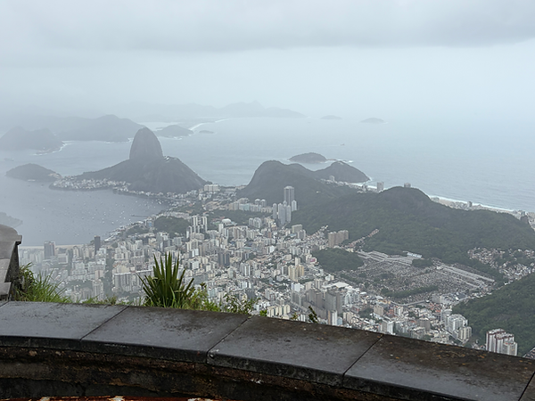
View of Rio de Janiero from Sugarloaf Mountain.

Another view of Rio de Janiero from Sugarloaf Mountain.
Note Christ the Redeemer in the background.

Sugarloaf Mountain.

Jaqueira (Jackfruit) tree. A member of the fig or breadfruit family.
The jackfruit is the largest tree fruit, reaching as much as 120 pounds (55 kg).

Monkey (actually a common marmoset) at Sugarloaf mountain.

Feijoada. Traditional meal of Brazil. Black beans, pork loin, and sausage. Served with rice, kale, orange slices, and pumpkin kibebe.

Pam wanted to see a 'Samba' dance show. So 'we' went.

Cocacabana Palace. Our hotel. Really, really nice.

Day 3, Wednesday, January 21, 2026
Start:
Copacabana Palace, Rio de Janeiro
End:
Copacabana Palace, Rio de Janeiro
Distance Traveled:
0
Major Highlights: Carnaval Experience, Copacabana Beach
It was a cloudy/rainy/showery day, so we didn't spend much time at the beach. Instead we toured one of the warehouses, where they were preparing floats and costumes for the upcoming Carnaval parade. As you might know, Carnaval is a big deal in Rio de Janeiro. They have a dedicated parade route with permanent stands. The parade is in about 3 weeks with tickets costing up to $2000.Floats and costumes are judged, and the competition is fierce. As such, we were not allowed to take any pictures of what we saw and the work they were doing. However, Pam was allowed to try on on one of the costumes.
Pam dressed up as a Carnaval entertainer.

With Carnaval Samba dancers.

One of the many Favelas (or slums) in Rio de Janeiro.

Copacabana Beach.

View of our hotel from Copacabana Beach.

Day 4, Thursday, January 22, 2026
Start:
Copacabana Palace, Rio de Janeiro
End:
Ship Oceania Marina
Distance Traveled:
0
Major Highlights:
Embarkation Oceania Marina
Pam before boarding.

Oceania Marina.

Oceania Marina.

Yup Star Ferris Wheel.

Leaving Rio de Janeiro. Sugarloaf Mountain at night.

Day 5, Friday, January 23, 2026
Port: Ihla Grande, Brazil
Distance sailed since last port:
72.6 nm (83.5 statue miles)
Total distance sailed:
72.6 nm (83.5 statue miles)
Major Highlights:
Ihla Grande
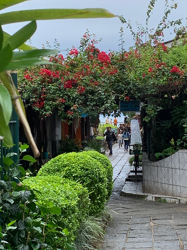
Ihla Grande is an island located off the coast of Brazil. For many years, the island was closed by the Brazilian government because it housed a leper colony and then a top security prison containing the most dangerous prisoners within the Brazilian penal system. The prision was closed in 1994, and the island is now a state parkland. The island has virgin Atlantic rainforest, undeveloped tropical beaches, and one small former fishing village called Abraao, that is now exceedingly touristy. Cars are not allowed on the island, except for a single garbage truck, fire truck, school bus, and police car.
Ihla Grande, Brazil. I guess we shouldn't be surprised to have rain in the rain forest during rainy season.

Ihla Grande, Brazil

Black Beach, Ihla Grande, Brazil

An abandoned aqueduct in Ihla Grande, Brazil. Built in 1893, it was used to carry water from the Abraao stream headwaters, to the Lazaretto quarantine station/prison.

Remnants of Lazaretto prison Ihla Grande, Brazil

Street view, Ihla Grande, Brazil

Street view, Ihla Grande, Brazil
Day 6, Saturday, January 24, 2026
Port: Santos (Sao Paulo), Brazil
Distance sailed since last port:
163.7 nm (188.4 statue miles)
Total distance sailed:
236.2 nm (271.8 statue miles)
Major Highlights:
Sao Paulo
From small fishing village yesterday to Sao Paulo today. Sao Paulo has a population of 23 million, making it one of the largest in the world.
Independence Museum, Sao Paulo, Brazil.

Independence Museum, Sao Paulo, Brazil.

View from steps of Independence Museum, Sao Paulo, Brazil.

View from steps of Independence Museum, Sao Paulo, Brazil.

Large tree near Pinacoteca de São Paulo.

View of Santos Port as we are leaving.

Rainbow over stern of sthip as we sail away.

Day 7, Sunday, January 25, 2026
Port: Balneario Camboriu
Weather: Sunny, High 82 F, Low 70 F
Distance sailed since last port:
225.2 nm (259.0 statue miles)
Total distance sailed:
465.5 nm (535.3 statue miles)
Major Highlights: Cable car ride to Atlantic Forest Station. Schooner (boat) ride back to port.
Balneario Camboriu was once called the 'Miami' of Brazil. It is now called the 'Dubai' of Brazil. Very clean, very modern city. Beautiful and clean beaches. Poplulation of ~ 150,000 in winter, over 1 million in summer (which is now). I was impressed by how nice the place is. A fair number of famous Brazilian soccer plyers live here.
Balneario Camboriu

Balneario Camboriu

Balneario Camboriu

Balneario Camboriu


Day 8, Monday, January 26, 2026
At sea
Next Port: Montevideo, Uruguay
Weather: Sunny, 86 F (at 8 AM)
Distance sailed since last port (as of 8 AM):
277.1 nm (318. 6 statue miles)
Total distance sailed (as of 8 AM):
741.8 nm (853.1 statue miles)
Major Highlights: Ax throwing contest, team trivia, mini golf, cooking class for Pam, and three separate lectures on wildlife off the coast of South America.
Day 9, Tuesday, January 27, 2026
Port: Montevideo (mon-teh-vee-DAY-oh), Uruguay
Weather: Sunny, High 86 F, Low 73 F
Distance sailed since last port:
711.9 nm (818.7 statue miles)
Total distance sailed:
1175.9 nm (1352.3 statue miles)
Major Highlights: Tour of Montevideo
Montevideo has a poplutation of about 1.2 million. The entire country has a popluation of ~ 2.3 million. It produces enough food for 22 million people, so it is obvious that they export a lot of food. One of the food items I can vouch for is steak. You can get a beautiful, thick, flame broiled steak with all the fixings for less than $20.
We also learned why Montevideo is called Montevideo. It comes from when the spanish explored the Rio de la Plata. Mont means hill in Spanish, VI is Roman numeral 6, and deo is an abbreviation for east to west. Montevideo is the 6th hill east to west on Rio de la Plata. Now you know.
Montevideo, Uruguay.

Montevideo harbor. Several sunken ships.

Montevideo skyline from ship.

Playa de los Pocitos. Which literally translates to 'Beach of Small Water Holes'. Long ago, women would dig holes in the sand, fill with water, and wash clothes.

Estadio Centenario or 'Centenary Stadium'. Site of the inaugural 1930 FIFA World Cup, which Uruguay won.

Statue of the founder of Uruguay, José Gervasio Artigas, located in Independence Plaza, Montevideo.


The Legislative Palace of Uruguay.

The Legislative Palace of Uruguay.
View of Montevideo from atop city hall.

Montevideo Opera House.

Salvo Palace. 344 ft high. Finished in 1928. It was the tallest building in Latin America for a brief period, at its completion.

Old town Montevideo.

Gate to old town.


Office of the President of Uruguay.
Cathedral of Montevideo.

Day 10, Wednesday, January 28, 2026
Port: Buenos Aires, Argentina
Weather: Sunny, High 81 F, Low 70 F
Distance sailed since last port:
143.6 nm (165.1 statue miles)
Total distance sailed:
1316.7 nm (1514.2 statue miles)
Major Highlights: Brief tour of a couple of spots in Buenos Aires, the Tigre Delta.
Since this is my 4th visit (Pam's 3rd) to Buenos Aires, we decided to skip the traditional major tourist spots and do something a bit different. We took a boat tour of the Tigre Delta. Tigre is on the Rio de la Plata, just north of Buenos Aires, and is a series of islands interconnedted by the river. There are no roads. The only way to get around is by boat. Many mid- to upper-class Argentians have weekend/summer homes here. There are restaurants, a school, a grocery boat, etc.
Buensos Aires business district as seen from ship.

Buenos Aires as seen from ship.

Boca. A working class bairro in Buenos Aires. Home to the Boca Juniors soccer team (one of the best in Sourth America). Also has a area with a collection of bright colored shops and restaurants.

Boca.

Monument to General Manuel Belgrano. One of the main founding fathers of Argentian. He is equivalent to our George Washington.

Casa Rosada (the pink house). The official workplace of the the president of Argentina.

Cathedral of Buenos Aires. Pope Francis was Archbishop here before he bacame Pope.

Tigre Delta.

Tigre Delta.

Tigre Delta.

Tigre Delta.

Leaving Buenos Aires.

Day 11, Thursday, January 29, 2026
At sea
Next Port: Falkland Islands
Weather: Sunny, 81 F
Major Highlights: Ax throwing contest, team trivia, mini golf, and four separate lectures on the history of the Falklands and the wildlife off the coast of South America.
Oysters Rockefeller.

Lobster Thermidor.

Baked Alaska.

Day 12, Friday, January 30, 2026
At sea
Next Port: Falkland Islands
Weather: Sunny, 66 F (at 8 AM)
Distance sailed since last port (as of 8 AM):
360.0 nm (414.0 statue miles)
Total distance sailed (as of 8 AM):
1695.7 nm (1950.0 statue miles)
Major Highlights: Ax throwing contest, team trivia, mini golf, and three separate lectures on wildlife off the coast of South America.
Day 13, Saturday, January 31, 2026
At sea
Next Port: Falkland Islands
Weather: Sunny, 58 F (at 12 Noon)
Distance sailed since last port (as of 8 AM):
797.3 nm (916.9 statue miles)
Distance to Port Stanley (as of 8 AM):
370.1 nm (425.6 statue miles)
The days are starting to get longer and colder. Waves in the morning were about 4 ft. Afternoon about 6 ft.
Major Highlights: Ax throwing contest, team trivia, mini golf, two separate lectures on Antarctica, and mandatory presentations as per IAATO on environmental and safety practices for visitors to Antarctica.
Day 14, Sunday, February 1, 2026
Port: Port Stanley, Falkland Islands
Weather: Sunny, High 56 F
Distance sailed since last port:
1168.5 nm (1343.8 statue miles)
Total distance sailed:
2484.3 nm (2856.9 statue miles)
Major Highlights: Penguins, Port Stanley
The Falklands have a total population of about 3,000 people. There are about 240 sheep per person for a total of about 700,000 sheep. The Falklands are home to 5 of the 17 species of penguins.
Port Stanley is the largest city in the Falklands. It has a popluation of about 2,000 people. Some of the homes were moved brick by brick from England. Because of it's small population and isolation, the Falklands have retained many of the old English customs. Some say the Falklands are more English than England.
Port Stanley, Falklands from the ship.

Port Stanley, Falklands from the ship.

The land is rugged, treeless, and really only good for sheep and goats.

Port Stanley and the cruise ship in the background.


Rockhopper penguins.

Rockhopper penguin.

Rockhopper penguin.

Rockhopper penguin video. Watch and you can see why they are called Rockhoppers.

Colony of Rockhopper penguins and cormorants.

King penguins.

King penguin. The bulge at the bottom is because he/she is sitting on an egg. You can just make out an egg on the penguin to the left.
They hold the egg on top of their feet. When their mate comes back from feeding, they pass the egg off.
They can't pick the egg up off the ground. So if they should ever happen to drop the egg, the egg/chick dies.

King penguins.

Gentoo penguins.

Gentoo penguin.

Video of Gentoo penguins.

Gentoo penguins. Note that the penguin in front has a chick.

Gentoo penguin with a chick.

Magallenic penguin.

Magallenic penguin in front of WWII coastal defense gun.


Cathedral of Stanley with crossed whalebones.
Having a cathedral is what makes Stanley a 'city' as opposed to a 'town'.

Video of King Penguin.

Day 15, Monday, February 2, 2026
At sea
Destination: Antarctic Pennisula
Weather: Sunny, 42 F (at 12 Noon)
Distance sailed since last port (as of 8 AM):
239.8 nm (275.8 statue miles)
Total Distance Sailed (as of 8 AM):
2722.9 nm (3131.3statue miles)
Wind:
42.4 kts out of the SW
Wind over the bow:
51.1 kts
Waves
~ 4.5 meters (14 ft)
It's a bit of a moderate ride.
Video of waves in pool.

The Drake passage going south wasn't too bad.
Video.

Day 16, Tuesday, February 3, 2026
Antarctic Peninsula
Weather: Overcast, 36 F (Warmer than home!) with almost 24 hours of sunlight.
Distance sailed since last port (as of 8 AM):
630.7 nm (725.3 statue miles)
Total Distance Sailed (as of 8 AM):
3113.8 nm (3580.9statue miles)
Major Highlights: Antarctc Scenery, Seals, Whales, and thousands upon thousands of Penguins.
Approaching the Antarctic Peninsula.

The Antarctic Peninsula.

Whale.

Whale.
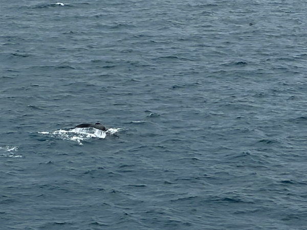
Whale.

Approaching the Antarctic Peninsula.

Half Moon Island.

Half Moon Island.

Argentina Antarctic Research Station.

Argentina Antarctic Research Station.

Half Moon Island.

Antarctica.

Antarctica.

Antarctica.

Humpback Whale.

Humpback Whale.

Humpback Whale.

Entrance to center of Deception Island.

Day 17, Wednesday, February 4, 2026
Cruising the Antarctic Peninsula.
Distance sailed since last port (as of 8 AM):
872 nm (1002.8 statue miles)
Total Distance Sailed (as of 8 AM):
3351.1 nm (3853.8 statue miles)
Major Highlights: Antarctic Scenery, Penguins, Orca Whales
I learned today that an 'Ice Pilot/Captain' boarded in the Falkland Islands. He is a fully qualified ship captain who has spent years navigating the Antarctic waters. He understands how icebergs move with the wind and current, and which icebergs not to get to close to. In summary, his job is to make sure we don't have a 'Titanic' moment.
Also, I found it very hard to capture the size and grandeur of Antarctica. The pictures below don't do it justice. Moutains 6000 ft tall with glaciers emptying into the ocean.
Gerlache Strait, Antarctica.

Gerlache Strait, Antarctica.

Gerlache Strait, Antarctica.

Gerlache Strait, Antarctica.

Gerlache Strait, Antarctica.

Gerlache Strait, Antarctica.

Gerlache Strait, Antarctica.

Iceberg in Gerlache Strait, Antarctica. This 'small' iceberg was taller than our 15 deck high ship.

Iceberg in Gerlache Strait, Antarctica.

Surfacing whale, Gerlache Strait, Antarctica.

Research vessel Noosfera. Operated by the National Antarctic Scientific Center of Ukraine.

Paradise Bay, Antarctica.

Paradise Bay, Antarctica.

Paradise Bay, Antarctica.

Paradise Bay, Antarctica.

Paradise Bay, Antarctica

Paradise Bay, Antarctica. Dead calm seas.

Brown Station. An Argentine Antarctic base and scientific research station.

Brown Station. An Argentine Antarctic base and scientific research station.

Orca Whale.

Orca Whale.

Time lapse video of sailing through Paradise Bay.

Day 18, Thursday, February 5, 2026
Cruising the Antarctic Peninsula.
Distance sailed since last port (as of 8 AM):
1092.6 nm (1256.9 statue miles)
Total Distance Sailed (as of 8 AM):
3571.7 nm (4107.4 statue miles)
Major Highlights: Antarctic Scenery, Penguins, Orca Whales
Admiralty Bay, Antarctica.

Admiralty Bay, Antarctica.

Admiralty Bay, Antarctica.

Admiralty Bay, Antarctica.

Admiralty Bay, Antarctica.

Admiralty Bay, Antarctica.

Admiralty Bay, Antarctica.

Admiralty Bay, Antarctica.

Minke whale.


Henryk Arctowski Polish Antarctic Station.

Ecuador Antarctic Outpost.

Comandante Ferraz Antarctic Station. Brazil's permanent Antarctic research station.

Video of Penguins swimming.


Day 19, Friday, February 6, 2026
At sea
Destination: Ushuaia, Argentina (Cancelled due to high winds).
Next destination: Punta Arenas, Chile
Weather: Overcast, 38 F
Distance sailed since last port (as of 8 AM):
1371.6 nm (1577.3 statue miles)
Total Distance Sailed (as of 8 AM):
3850.7 nm (4428.3statue miles)
Wind:
15.0 kts out of the NW
Waves
~ 3.5 meters (10 ft)
Day 20, Saturday, February 7, 2026
At sea
We were supposed to be in Ushuaia, Argentina but the port stop was cancelled due to high winds. To make matters worse, we 'drove by' Ushuaia without stopping.
Next destination: Punta Arenas, Chile
Weather: Partly Cloudy, 47 F
Distance sailed since last port (as of 8 AM):
1680.8 nm (1932.9 statue miles)
Total Distance Sailed (as of 8 AM):
4165.1 nm (4789.9 statue miles)
Wind:
34 kts out of the SW
Waves
< 1 meter (2-3 ft)
Ushuaia, Argentina

Ushuaia, Argentina

Beagle Channel, Chile

Hanging Glacier with Waterfall into Beagle Channel.

Sailing the Beagle Channel, Chile

Day 21, Sunday, February 8, 2026
Port: Punta Arenas, Chile
Weather: Overcast, High 62 F, Low 46 F
Distance sailed since last port:
1943.6 nm (2235.1 statue miles)
Total distance sailed:
4427.9 nm (5092.1 statue miles)
Major Highlights: Magdalena Island penguin reserve and dry land after 7 days (including 3 days of the Drake passage). Magdalena Island penguin reserve.
Punta Arenas overlooks the Strait of Magellan and was once an important stop for ships rounding the tip of South America during the California Gold Rush. With the opening of the Panama Canal the port's importance diminished, but the area still retains a heritage of English sheep ranchers and Portuguese sailors.
Punta Arenas from ship.

Statue of Ferdinand Magellan.

Cathedral of Punta Arenas.

Cathedral of Punta Arenas.

Magdalena Island Penguin Reserve.


Magellanic penguins.

Magellanic penguin.
Magellanic penguin.

Magellanic penguin.

Magellanic penguins.

Magellanic penguins.

Day 22, Monday, February 9, 2026
Cruising the Chilean Fjords
Next port: Puerto Chacabuco, Chile
Weather: Foggy with Light Rain, 46 F
Distance sailed since last port (as of 8 AM):
174.3 nm (200.4 statue miles)
Total Distance Sailed (as of 8 AM):
4604.8 nm (5295.5 statue miles)
Wind:
37 kts out of the NW
Waves
< 1 meter (2-3 ft)
Day 23, Tuesday, February 10, 2026
Cruising the Chilean Fjords
Next port: Puerto Chacabuco, Chile
Weather: Partly Cloudy, 47 F
Distance sailed since last port (as of 8 AM):
590.9 nm (590.9 statue miles)
Total Distance Sailed (as of 8 AM):
5021.4 nm (5774.6 statue miles)
Wind:
5 kts out of the W
Waves
Calm
Chilean Fjords.

Chilean Fjords.

Chilean Fjords.

Day 24, Wednesday, February 11, 2026
Puerto Chacabuco, Chile
Weather: Partly Cloudy, 57 F
Distance sailed since last port (as of 8 AM):
909.9 nm (1046.4 statue miles)
Total Distance Sailed (as of 8 AM):
5337.8 nm (6138.5 statue miles)
Major Highlights: Visit to town of Coyhaique a city in Chile's Aysén Region and short hike in Simpson river National Reserve.
Port of Chacabuco, Chile.

Coyhaique town square.

In almost every town we have ever visited in Chile, stray dogs are everywhere. Coyhaique was no exception.

Simpson River National Reserve.


Simpson Valley.
Simpson River.

The Nalca or Chilean rhubarb plant.

Simpson River.

Port of Chacabuco, Chile.

Port of Chacabuco, Chile.

Chilean fjords.

Chilean fjords.

Prime rib dinner.


Dessert. Chocolate Fudge Brownie, Key Lime Pie, Apple Pie, Caramelized New York Cheesecake.
Day 25, Thursday, February 12, 2026
Castro, Chile
Weather: Partly Cloudy, 59 F
Distance sailed since last port (as of 8 AM):
249.9 nm (287.4 statue miles)
Total Distance Sailed (as of 8 AM):
5587.7 nm (6425.9 statue miles)
Major Highlights: Castro, Chile and UNESCO World Heritage Churches
Port of Castro, Chile.

The Church of Chonchi (or St. Charles Borromeo), located on Chiloé Island in southern Chile. A historic wooden church designated as a National Monument of Chile in 1971. It is part of the traditional wooden architecture of the region and features a distinct yellow and blue façade.

The Church of Chonchi.

The Church of Nercón (Our Lady of Grace Church). A UNESCO World Heritage Site. The Church was constructed around 1890, from cypress and larch wood. It is 65 feet long, 45 feet wide, and has a 75 foot high tower. Constructed entirely without nails.

The Church of Nercón.

Garden in front of the Church of Nercón.

The Church of Nercón cemetery.

The Church of San Fransisco in Castro Chile. It was declared a Chilean National Monument in 1979 and UNESCO World Heritage Site in 2000.

The Church of San Fransisco in Castro Chile.

Stilt house in Castro Chile. Originally 19th-century fishermen's homes, they feature native wood construction (luma/cypress) and are now largely boutique hotels, hostels, and shops.
The tide range is 18 feet.

Day 26, Friday, February 13, 2026
Puerto Montt, Chile
Weather: Partly Cloudy, 66 F
Distance sailed since last port (as of 8 AM):
117.4 nm (135.0 statue miles)
Total Distance Sailed (as of 8 AM):
5704.3 nm (6559.9 statue miles)
Major Highlights: Puerto Varas, Chile and Frutillar, Chile
Puerto Montt, Chile from ship. Calbuco volcano in background.

Puerto Montt from ship. Calbuco volcano in background.

Osorno volcano as seen across Lake Llanquihue from Puerto Varas, Chile

Osorno volcano and Calbuco volcano as seen across Lake Llanquihue from Puerto Varas, Chile


Our ship in Puerto Montt.
Day 27, Saturday, February 14, 2026
At sea
Last day on cruise ship.
Weather: Partly Cloudy, 68 F
Distance sailed since last port (as of 8 AM):
246.9 nm (283.9 statue miles)
Total Distance Sailed (as of 8 AM):
5950.2 nm (6842.7 statue miles)
Day 28, Sunday, February 15, 2026
Disembark ship
Weather: Sunny, High 84, Low 59 F
Total Distance Sailed:
6307.7 nm (7253.9 statue miles)
San Antonio, Chile cruise port to
Santiago, Chile airport
67 miles
LATAM Flight LA 255:
Santiago (SCL) to Puerto Montt (PMC)
569 miles
Puerto Montt airport to
AWA Hotel, Puerto Varas
Los Lagos, Chile
33 miles
View from our hotel room. Lake Llanquihue with Osorno Volcano in the background.

Video of our visit to Antarctica provided by Oceania to all guests at end of cruise.

Day 29, Monday, February 16, 2026
AWA Hotel, Puerto Varas, Los Lagos, Chile
Weather: Sunny, High 70, Low 50 F
Major Highligths: 3.5 mile hike and 6 mile E-bike ride.
Hike through Chilean rain forest. As always, I'm in front, Pam is bringing up the rear.

Osorno volcano.


Osorno volcano.
Osorno volcano.

Calbuco volcano.

Relaxing on the hotel deck with Osorno volcano in the backgroun.
My first cigar of the trip.

Day 30, Tuesday, February 17, 2026
AWA Hotel, Puerto Varas, Los Lagos, Chile
Weather: Cloudy, Rain Showers, High 67, Low 46 F
Major Highligths: 5 mile forced march to see a waterfall and the largest/tallest tree in South America. This old man is getting to old walk 5 miles in the rain on rough terrain. But we did it.
Alerce Costero National Park.

Salto Río Chaicas or Chaicas River Falls.

Salto Río Chaicas.

Alerce Milenario is the largest tree in Chile's Alerce Costero National Park.
At an estimated age of 5000 years, it is possibly the oldest tree in the world.

Alerce Milenario tree.

Alerce Milenario tree.

Day 31, Wednesday, February 18, 2026
AWA Hotel, Puerto Varas, Los Lagos, Chile
Weather: Clear, High 67, Low 53 F
Major Highligths: Kayaking the Reloncaví Fjord.
Kayaking the Reloncaví Fjord.

Kayaking the Reloncaví Fjord.
A lesson that I always seem to forget... but never double Kayak with your wife. Words were exchanged.

Sea Lion.

Sea Lion.

Lunch Stop at Yolonda's farm.

About half-way through our trip, we stopped at the farm house shown above for lunch. The farm is owned by 'Yolonda'. Yolonda is 80 years old, was born in the house and has lived here all her life. The house is very isolated from the outside world. It has an outhouse for a bathroom and she has to walk 1 hour to get to the nearest road. She got electricity in 2000, The only source of heat for the house is the wood burning stove in the center of the kitchen.
To make a little extra money, Yolonda prepares meals for passing Kayakers. She prepared a great meal of salad, fried fish, and boiled potatoes.

Yolonda's front yard.

Kayaking the Reloncaví Fjord.

Video of kayaking the Reloncaví Fjord.

Day 32, Thursday, February 19, 2026
AWA Hotel, Puerto Varas, Los Lagos, Chile
Weather: Clear, High 66, Low 47 F
Major Highligths: A 'Culinary' Experience
For reasons that can only be attributed to our travel agent not knowing me very well, she signed us up for a hands-on 'Culinary' experience. We visited a local farm and harvested fresh vegetables to prepare a traditional Chilean meal.

Harvesting greens.

Me pretending to enjoy picking greens.

Picking tomatoes.


Our bounty.
Pam making salad from our bounty.
It seems strange to actually 'pay' someone for the experience of prepaing and cooking your own food.
I thought that was why restaurants were invented. To pay someone else to do the work.

The farm owner (Cornelius) and her daughter grilling vegetables.

Our meal.

Our driver (Ercelia) and guide (Phlippe) for the past week.

Lunch.

View of the Osorno volcano on the drive back to the hotel.

Day 33, Friday, February 20, 2026
AWA Hotel, Puerto Varas, Los Lagos, Chile
Weather: Clear, High 66, Low 47 F
Major Highligths: Visit to Chiloé Island to see Humboldt and Magellanic penguins.
Playa de Cucao or Cucao Beach.

They have an interesting way to load and unload the car ferries that probably wouldn't work in the U.S. The basically have an industrial sized boat ramp, they 'beach' the ferry on the boat ramp, lower a car ramp, and the cars drive on and off. No piers. Not cleats or mooring lines. The boat is just held there with the boat motors pushing against the ramp.

Ferry to Chiloé.

A Chilean Hawk.

Unusual to see a large tour bus parked on a beach.

Puñihuil Natural Monument on Chiloé Island, Chile. Magellanic and Humboldt penguins nest on the three islands seen. To get up close to the penguins you have to take a boat.

One of the boats used to go see the penguins.

To keep the tourists from getting their feet wet, the transfer them to the boat using 'carts'. This video shows the process. Again, something you would never see in the US.
The reason they have to do this is that docks/piers are not allowed in the National Monument.

Pam on the boat, with our guide Phillipe right behind.

Humboldt penguin.

Humboldt penguin.

Day 34, Saturday, February 21, 2026
Transfer from AWA Hotel, Puerto Varas, Los Lagos, Chile to
Rio Yelco Lodge, Chaitén, Los Lagos, Chile
Flight Distance: 95 miles
Flight Time: 45 minutes
If we had driven: Driving distance 151 miles
If we had driven: Driving time: 7 hrs 40 minutes (it would have included two ferry crossings)
Weather: Partly Cloudy, High 61, Low 54 F
Airplane to Chaiten. Cessna Caravan. Commercial flight with 2 pilots. The pilots did everything including checking people in, loading luggage, the safey briefing, and unloading the luggage at the end of the flight.

We flew at 3500 feet with an indicated airspeed of about 150 kts.
Great view of the Chilean Alps.

View from the plane.

View of the runway as we are landing in Chaiten.

View from the deck of Martin Pescador Lodge.

View from the window of our cabin.

Went fishing about an hour after arriving at the lodge.

First fish of the trip was this nice rainbow.

Day 35, Sunday, February 22, 2026
Rio Yelcho Lodge, Chaitén, Los Lagos, Chile
Fishing Area: Rio Futaleufú (Futaleufú River)
Weather: Clear, High 74, Low 54 F
The drive to Rio Futaleufu.

Jet boat launch.

Pam came with me today.
The guide set up a lawn chair on the stern of the boat for her.
She was like the 'Queen of the Nile'.

Rio Futaleufu.

Brown trout on the Rio Futaleufu.
We were looking for big fish, but all the fish we caught were small.

Lunch on an island.

Fishing the Rio Futaleufu.

Fish on.

View of Yelcho Lago (Lake Yelcho) on the drive back to the lodge.

View of Yelcho Lago (Lake Yelcho) on the drive back to the lodge.

Day 36, Monday, February 23, 2026
Martin Pescador Lodge, Chaitén, Los Lagos, Chile
Fishing Area: Rio Yelcho and Lago Yelcho (Yelcho River and Yelcho Lake)
Weather: Rainy, High 65, Low 45 F
Cloudy/windy/rainy day. Not the ideal conditions.

Heavy rains overnight turned the river muddy. Between that and the high winds, it was a tough day. However, a few fish were still caught.

Day 37, Tuesday, February 24, 2026
Transfer to Rio Rosselot Lodge, La Junta, Aysen Region, Chile
Fishing Area: Lago Rosselot (Rosselot Lake)
Weather: Clear, High 55, Low 46 F
Great day of fishing.
Lago Rosselot (Rosselot Lake).

First fish of the day.

Rainbow trout.

Brown trout.

Rainbow trout.

Lago Rosselot.

Brown trout.

Brown trout.

View of Rio Rosselot (Rosselot River) from our cabin.

Day 38, Wednesday, February 25, 2026
Rio Rosselot Lodge, La Junta, Aysen Region, Chile
Fishing Area: Lower Rio Figueroa (Figueroa River)
Weather: Clear, High 70, Low 43 F
Rio Figueroa (Figueroa River).

Rio Figueroa Canyon.

Rio Figueroa Canyon.

Brown Trout.

Rainbow Trout.

Brown Trout.


Lunch.
Brown Trout.

Brown Trout.

Brown Trout.

Rio Figueroa.

Rio Rosselot Lodge.

Day 39, Thursday, February 26, 2026
Rio Rosselot Lodge, La Junta, Aysen Region, Chile
Fishing Area: Rio Rosselot (Rosselot River)
Weather: Partly Cloudy, High 65, Low 52 F
Rio Rosselot

Brown Trout.

Brown Trout.

Brown Trout.

Rainbow Trout.

Rainbow Trout.

Lunch.

Brown Trout.

Brown Trout.

Brown Trout.

Rio Rosselot Lodge.

Day 40, Friday, February 27, 2026
Rio Rosselot Lodge, La Junta, Aysen Region, Chile
Fishing Area: Middle Rio Figueroa (Figueroa River)
Weather: Cloudy with some rain, High 60, Low 52 F
It was a bad day to be a trout. We caught lots of fish.
Rio Figueroa (Figueroa River)

Brown Trout.

Brown Trout.

Rainbow Trout.

Pam getting casting lessons.
Another lesson, and thankfully a lesson I remembered, is never give your wife casting lessons.

The first trout Pam has ever caught.

Rainbow Trout.

Rainbow Trout.

Rainbow Trout.

Brown Trout.

Brown Trout.

Day 41, Saturday, February 28, 2026
Homeward Bound.
Starting at 7:00 AM on Saturday, February 28, 2026.
1) Transfer from Rio Rosselot Lodge to Chaiten Airport: 89.5 miles 2 hrs 15 minutes drive time.
2) Chartered Pewen Airlines flight from Chaiten Airport to La Paloma Airport, Puerto Montt, Chile:
95 miles, 45 minutes.
3) Private van transfer from La Paloma Airport to Puerto Montt Airport, Puerto Montt, Chile: 12.9 miles, 35 minutes.
4) LATAM flight 310, Puerto Montt Airport to domestic terminal Santiago de Chile: 569 miles, 1 hour 43 minutes.
5) Reclaim luggage and walk to Santiago de Chile international terminal. Recheck baggage.
6) LATAM flight 532 / Delta flight 6060, Santiago de Chile to JFK airport: 5125 miles, 10 hours 30 minutes.
7) Clear customs and immigration, reclaim baggage, recheck baggage.
8) Delta flight 5733, JFK to Boston Logan airport: 186 miles, 1 hour 12 minutes.
9) Reclaim luggage. Private transfer from Boston Logan to home: 69.2 miles, 1 hours 30 minutes
Home at 2:00 PM on Sunday, March 1, 2026, then:
10) Shovel 30+ inches of snow.

bottom of page